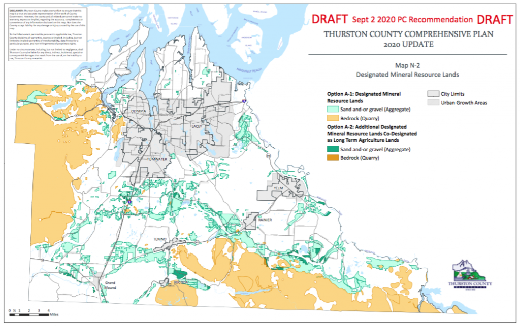
On November 24th, Thurston County’s Board of Commissioners (BoCC) will hold a public hearing to update the Mineral Lands Policy of the County’s Comprehensive Plan and adopt mining-related ordinances. The focus of this update is the approval of a new map identifying the County’s mineral designated lands and the options that arise with specific mapping circumstances.
This issue is complicated, even to those who have been following it for years. This article describes concerns about the proposals and options and lists how you can help.

Background
Thurston County, due to its glacial history, contains excellent quality gravel as well as many wetlands and prairies, the critical areas for our diverse habitats and wildlife. Unfortunately, the most-valuable gravels and the best habitats overlap. Also, mining operations are not the best neighbors to our parks, protected for their habitats.
To protect gravel and quarry rock for present and future use, the State of Washington, through the Growth Management Act, required counties to map their mineral lands. Once a parcel is designated as Mineral Resource Lands (MRL), mining activities are given priority over other resource considerations. Critical areas within the parcel(s) can be protected from mining activities as part of the permitting process, but that requires vigilance and financial resources from neighbors and/or environmentally-concerned groups.
Currently, around 6,000 acres of land in unincorporated Thurston County are designated as mineral resource lands. Per the new map, around 140,000 acres will be designated, more than twenty times the present acreage. Future mine growth is unknown, but at stake is: the rural nature of our county; our farmland; the quality of our natural areas set aside for their healthy, unique and diverse habitat; and, last, but far from least, our aquifer, the sole clean water source for all our County’s needs.
You can help in two ways: (1) Send/present your comments to the BoCC at or before the hearing, and (2) sign an electronic petition that will be posted by Black Hills Audubon on its website in mid-November. We urge you to support the following:
Retain the 1,000-foot separation distance between mines and selected parks
A major source of contention between environmental stakeholders (BHAS, League of Women Voters, Nisqually River Council Citizens’ Advisory Committee, South Sound Farmland Trust, and Sierra Club) and those speaking for the mining industry has been a Comprehensive Plan Policy, established in 1994, that no mine excavation can occur closer than 1,000 feet from 38 already existing natural area parks, a subset of all parks. This policy is important for protecting the complicated and sensitive water pathways in gravels. Thurston County’s Critical Area Ordinances do not address the effects of punctures through the till between surface water and the county aquifer. Prairie and wetland plants and animals are sensitive; even a six- to twelve-inch change at key times can negatively affect successful reproduction. A 1,000-foot separation distance is crucial to protect sensitive areas from impacts that can occur up-gradient and down-gradient of gravel pits as deep as 90 feet.
No Co-designation of Mineral Lands and Long-Term Agriculture Lands: Support Option A-1
Should the county co-designate Mineral Resource Lands (MRL) and those lands designated as Agricultural Lands of Long-Term Commercial Significance? Under the new map there will be at least 140,000 acres zoned MRL, while only 15,878 acres of farmland are zoned as Long-Term Agriculture. (Total farmland is 62,000 acres.) 2,000 of those specially zoned farm acres are at risk of being zoned MRL if co-designation is approved (Option A-2). Community comments received to-date strongly support Option A-1, no co-designation.
Option E Recommendation: Support Option E-1 as modified below.
Often only a portion of a parcel has MRL status. How much of a land parcel must be designated for mining and accessory activities to be allowed on the entire parcel? We propose:
In the case of a single parcel, 25% of the acreage must be MRL-designated, 2) similarly, in the case of multiple contiguous parcels, 25% of the combined property must be MRL-designated. Areas in the 1,000-foot separation distance from a park are not eligible to apply for a permit unless the parkland is donated by a mining company.
The mining community opts for E-3 which could increase Mineral Resource Lands to 210,000 acres from the mapped 140,000 acres. This is a significant increase.
The County and the miners keep on saying designation does not mean a permit. But it does mean that mining will have priority over other natural resources and land activities in a permit hearing for a mine.
In Conclusion
BHAS will send out an alert in mid-November advising BHAS members that an electronic petition has been placed on its webpage. The petition will be the position of the environmental stakeholders, including BHAS. We do ask that petition signers be Thurston County citizens or people who have a personal connection to Thurston County. Please sign to protect our critical areas, Parks, rural character, and Agricultural Land of Long-Term Commercial Significance.
We also encourage individual comments. County Commissioners really appreciate and pay attention to constituents’ insights and stories. For greater detail, the County analysis of Mineral Lands can be found at:
https://www.thurstoncountywa.gov/planning/Pages/comp-plan-update.aspx
Scroll down to Chapter 3 and find references to Mineral Lands. Personal comments may be sent to maya.teeple@co.thurston.wa.us.


